Science project
How Fast Does a Seismic Wave Travel?
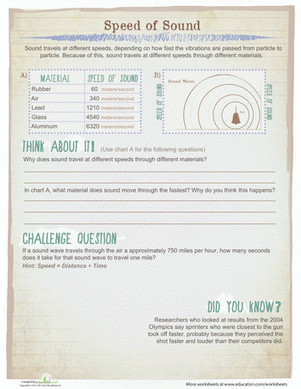
Seismic waves travel through the earth during an earthquake. They occur when stress at a plate or other regions on the earth is released. Waves that travel through the crust are called surface waves. These cause most of the damage associated with earthquakes. Waves that travel through deeper layers are called body waves. These may be divided into primary and secondary waves. The strength of seismic waves is measured by an instrument called a seismometer. A network of seismometers is run the Northern California Earthquake Data Center, at the University of California, Berkeley. Evaluating the data from these earthquake substations allows students to track how an earthquake travels through the crust and measure how fast the seismic waves travel.
Problem:
By studying actual earthquakes, students will becomes familiar with seismic waves, different types of waves and how fast they travel.
Materials:
- Computer
- Internet connection
Procedure:
- Go to the website “Historic Worldwide Earthquakes” found in the Bibliography below and identify which earthquakes you wish to evaluate. Tracking seismic waves in 10 or fifteen different earthquakes is very helpful in understanding these phenomena.
- Note the magnitude, longitude, latitude and depth, and time (measured as Coordinated Universal Time) of each of the earthquakes you are interested in.
- Go to the website “Make your Own Seismogram!” The directions there are very straight forward.
- Select a station. If the acronyms for station location are confusing, check out the link associated with the Berkeley Seismological Laboratory called “Map of BSDN” found in the Bibliography. This map demystifies these location acronyms.
- Select the “long period” data channel for earthquakes that are very far from the station (i.e. an earthquake in Japan). Use the broadband channel for earthquakes that are local to the station (i.e. the Northridge or Loma Prieta quakes).
- 6. Set the time period so that your beginning time is 12 hours before the time you found in step #2, and the ending time is 12 hours after that time.
- Since default parameters work find, so go ahead and click “Create Plot.” You will get a seismogram covering that time period. Information on the left hand side of the seismogram refers to time. Look for the time roughly when your earthquake occurred – and carefully study when the waves first made their appearance on your seismogram. Subtract this time from the time the earthquake started at the epicenter.
- You are now ready to determine how fast the seismic waves associated with your earthquake traveled. Get the longitude and latitude of the substation that you are using. This information is available near the top of the page associated with the Berkeley Seismological Laboratory called “Map of BSDN” that you used in step #4.
- Go to the webpage “Surface Distance between Two Points of Latitude and Longitude” found in the bibliography. Use the calculator there to determine the distance between the epicenter and the substation you chose. Using this calculation requires a quick conversion from degrees expressed as decimals to degrees expressed as degrees, minutes and seconds. This can be done on the website
- Divide the value you calculated in step number # 7 by the distance calculated in step #9. The result is how fast the seismic wave travel.
- Repeat with different earthquakes.
Education.com provides the Science Fair Project Ideas for informational purposes only. Education.com does not make any guarantee or representation regarding the Science Fair Project Ideas and is not responsible or liable for any loss or damage, directly or indirectly, caused by your use of such information. By accessing the Science Fair Project Ideas, you waive and renounce any claims against Education.com that arise thereof. In addition, your access to Education.com's website and Science Fair Project Ideas is covered by Education.com's Privacy Policy and site Terms of Use, which include limitations on Education.com's liability.
Warning is hereby given that not all Project Ideas are appropriate for all individuals or in all circumstances. Implementation of any Science Project Idea should be undertaken only in appropriate settings and with appropriate parental or other supervision. Reading and following the safety precautions of all materials used in a project is the sole responsibility of each individual. For further information, consult your state's handbook of Science Safety.


